
Map 1. The borders of the Huron Tract Land Trust Conservancy within the original Huron Tract’s boundaries.
Where Is Here?
In 1827, some 2.2 million acres on the eastern side of Lake Huron were ceded to the British Crown from a part of the Anishinaabeg (Chippewa) Nation. One year earlier, the Crown had already “sold” some 1 million of those acres to the Canada Company.
How is this possible? There was a “provisional treaty” signed before the 1826 Canada Company purchase. So one year after the provisional Treaty #27½ and one year before the Huron Tract Treaty #29 solidified the sale, the land was already “in the hands” of the Canada Company, and those lands remained under the influence of the Canada Company until the 20th century. Whether the Crown sold the whole or part of the Huron Tract to the Canada Company prior to Huron Tract Treaty #29 can be deemed to be of little consequence. Most of those 2.2 million acres were referred to as “the Huron Tract,” which included the present-day counties of Huron, Perth, Middlesex, and Lambton. The modern map labelled Map 1 shows the borders of the so-called Huron Tract Land Trust Conservancy within the original Huron Tract’s bounds and roughly corresponding to Huron County, only slightly larger.
But even this was only a small part of the land settled and continuously travelled by Indigenous people all around Lake Huron. The eastern shore of Lake Huron was a “highway” of hunting, fishing, trade, and settlement from Sault Ste Marie to Detroit.
Map 2. Ipperwash Commission of Inquiry, plate 2 (2004)
This area (Huron County) was more than a casual hunting ground. Indigenous populations and settlements shifted over the past 1,000 years, but this land was home to tens of thousands of First Nations people. They can be divided into two major groups, as we have seen, based on the languages they spoke and continue to speak: to the north were mainly Algonquian-speaking (Anishinaabemowin) people, while the Iroquoian-speaking groups (Seneca, Mohawk, Oneida, Huron, etc.) were based to the south and east. The Potawatomi Nation (perhaps what Champlain noted as the “Nation of Fire” or “Fire Nation”) were undoubtedly south of this area, likely located not far past the St. Clair River into Michigan. But the Potawatomi also lived among Anishinaabeg people settled all around the Lake Huron basin in “Three Fire” Anihsinabeg communities. A common narrative is that this area was dominated by the Attawandaron or “Neutral” people until they were either pushed out or assimilated into the Huron nation in the mid-1600s. The Huron population, in turn, was decimated by disease and by conflict with the Iroquois Confederacy during the Beaver Wars of 1648–1701. The Huron—also called Wendat—and a related group, the Wendat, eventually moved west, after which Anishinaabe nations (Ojibwe, Potawatomi, and Odawa) moved into southwestern Ontario. In the Anishinaabeg tradition, the Sarnia area is called Aamjiwnaang and extends all around the southern end of Lake Huron, from the Blue Point (Plympton-Wyoming and southern Bosanquet townships) to near Windsor-Detroit and north into Michigan (Plain, The Plains of Aamjiwnaang). My perception is that, although the “Neutral” Iroquois are not around this area anymore, their story is about much more than just simple extinction that left the land open for Ojibwe settlement and then land surrender. As I understand my history, both Anishinaabe and Iroquoian people have fought over and also lived in peace on these lands, including Huron County, for at least a thousand years, and both Nations have been important players in the formation of British North America and the modern Canadian nation-state.
Map 3 shows the movement of the many different nations during the mid-1600s, but it must be viewed only as illustrative. “Forced movement” is a misleading term, as it is not clear who is forcing whom. The map is a snapshot in time and represents struggles for territory and trade routes among various First Nations, sometimes influenced by their alliances with the French and British.
Map. 3. Source: Sutori.com.
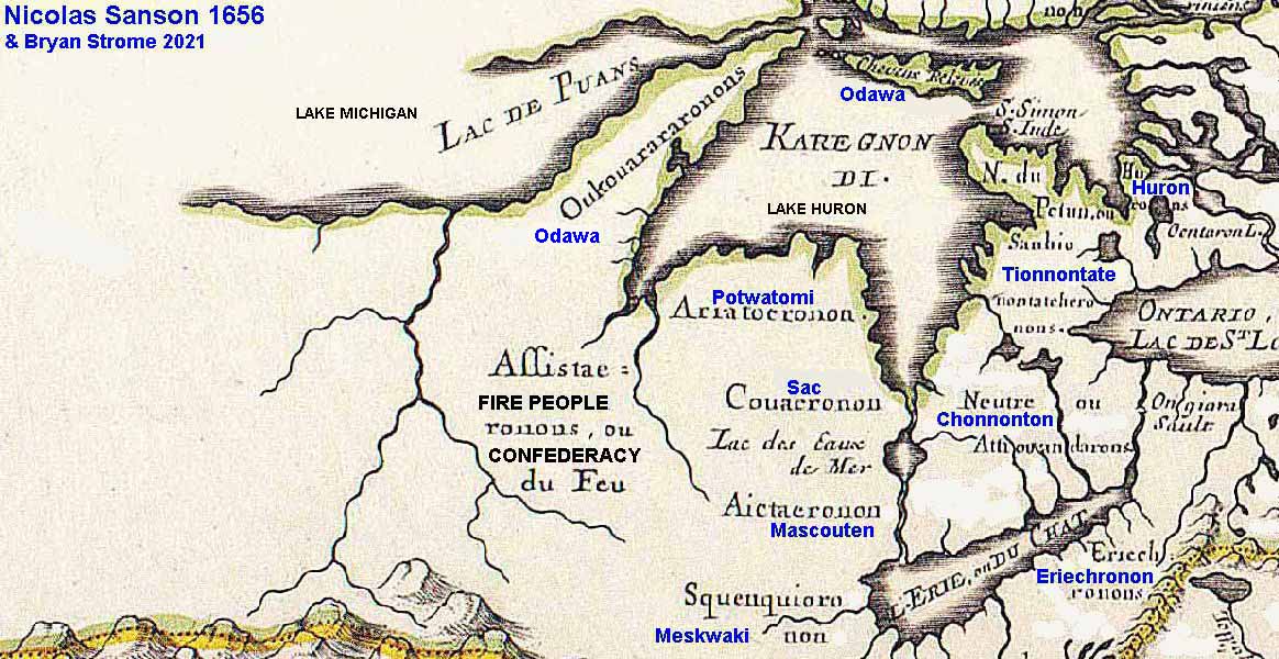
The 1656 map of the eastern Great Lakes (Map 4) shows the approximate regions of the various First Nations, as understood at that time. The area of Huron County was dominated by a group called the Neutral or the Attawandaron. Some First Nations believe that they called themselves Chonnonton (the label in blue), while others believe that term referred to a separate sub-group of the Neutral Confederacy. The map was made by the French cartographer Nicolas Sanson (1600–1667). The labels in blue were added in 2021 by Bryan Strome (Sanson, map).

Map 4. 1656 map by Nicolas Sanson.
The circa 1850s map of Canada West (Map 5) allows viewers to mentally picture the large-scale plans colonial administrators such as John Galt would have envisaged for the future. The totality of the land pictured previously comprised Indian territories, mostly signed by Anishinaabeg, which is to say Ojibwe/Chippewa, Potawatomi/Bodewaadmii, and Odawa. Outlined in the north and northeast are huge tracts of land that were untreatied and unceded at that time. The so-called “Saugeen Surrenders” follow that time period. The reserved lands to the south are considerably smaller and unnamed in this example of map making.

Map 5. John Tallis, Illustrated Atlas, 1851.
Sources
“Early Settlement of St. Mary’s.” St. Mary Museum website. http://stmarysmuseum.ca/settlers/1826.html
Huron Tract Belonging to the Canada Company. Libraries and Archives Canada. https://recherche-collection-search.bac-lac.gc.ca/eng/home/record?app=FonAndCol&IdNumber=4128135&q=huron%20tract
Ipperwash Inquiry: Historical Overview Testimony. https://wayback.archive-it.org/16312/20211207192904/http://www.attorneygeneral.jus.gov.on.ca/inquiries/ipperwash/history.html
Lee, R. The Canada Company and the Huron Tract 1826-1853: Personalities, Profits, and Poltics. Natural Heritage Books, 2004.
“Neutral Confederacy.” https://www.thecanadianencyclopedia.ca/en/article/neutral
Plain, David D. The Plains of Aamjiwnaang. Trafford Publishing, 2007.
Sanson, Nicolas. Map, 1656. With additional notes by Bryan Strome 2021. https://www.firstnationsseeker.ca/NicolasSanson1656MapC.jpg
Scott, James. The Settlement of Huron County. Toronto:Ryerson Press, 1966.
Sutori. “The Iroquois Indians” MAP. https://www.sutori.com/en/item/this-map-shows-the-placement-of-the-iroquois-confederacy-in-red-during-the-17t
Tallis, John. Illustrated Atlas. London and New York, 1851. Image taken from Welland Antique Maps and Prints https://www.wellandantiquemaps.co.uk/west-canada-south-west-ontario-john-tallis-j-rapkin-c1851.